

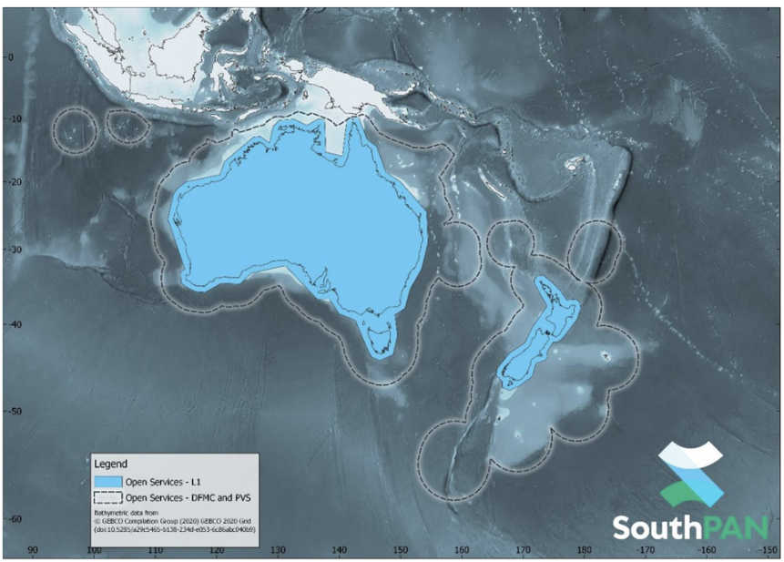
Statutory science agency Geoscience Australia and communications company Inmarsat Australia have embarked on an agreement to deliver more accurate and reliable satellite positioning services throughout Australia and New Zealand.
The $252 million agreement marks significant progress in the delivery of the Southern Positioning Augmentation Network (SouthPAN), which is a satellite-based augmentation system developed jointly by Australia and New Zealand.
SouthPAN can improve safety on mine and construction sites by accurately identifying the location of workers operating vehicles and heavy machinery.
It can also be used in agriculture through applications like precision spraying, yield mapping, controlled traffic farming, inter-row seeding and livestock management.
SouthPAN is a “next-generation SBAS”, which means that-in addition to delivering an Open Service augmenting the GPS L1-C/A navigation signal-we also transmit a Dual-Frequency Multi-Constellation (DFMC) Open Service augmenting the GPS L1-C/A and L5 navigation signals, and Galileo E1 and E5a navigation signals.
The aviation sector globally are working towards standardising DFMC services as the primary future SBAS, providing improved integrity and precision.
Precise positioning from SouthPAN will offer accuracy at as little as 10 centimetres: a significant improvement on previous accuracy of 5m to 10m. SouthPAN provides augmented and corrected satellite navigation signals directly from the satellite rather than through a mobile phone.
This allows as little as 10 centimetre level accuracy to be available everywhere, overcoming gaps in mobile, internet and radio communications. For example, this provides improved accuracy in our regional and remote areas, as well as in our maritime zones.
Reliable satellite service
The Australian Government has committed $1.4 billion towards the establishment and sustainment of SouthPAN over 19 years.
SouthPAN is expected to provide precise positioning and navigation services to support a number of sectors, including aviation, maritime, agriculture, surveying and emergency response.
Inmarsat Australia, which has since combined with Viasat, won the first contract in 2023 to deliver a satellite payload for SouthPAN.
The new agreement covers the continuation of services from satellites as well as a new payload to be carried on one of Inmarsat’s I-8 constellation of satellites.
It is also one step closer to SouthPAN being certified as a safety-of-life service for aviation, which is expected from 2028.
Minister for Resources and Northern Australia Madeleine King says the new agreement ensures a robust, reliable satellite service is working with the network of ground infrastructure to provide accurate precise positioning across the country and our maritime zones.

SouthPAN is delivered by Geoscience Australia in partnership with Toitū Te Whenua Land Information New Zealand, with early services available to both countries from 2022.
SouthPAN uses a number of distributed ground stations to monitor signals broadcast by Global Navigation Satellite System satellites, and compares each station’s known location with position data from the satellites.
The GNSS signal data and measurement information is sent to correction processing facilities. The facilities aggregate the data from all ground stations, produce error corrections and status information about the GNSS satellites, and format the data in a standardised series of messages.
These messages are sent to an uplink station, which transmits data to a satellite in geostationary earth orbit. The data is broadcast to all precise positioning users, who combine SouthPAN’s data with their own observations of GNSS satellites.
Inmarsat is a Viasat company and continues to power the digitalisation, decarbonisation and crew welfare of the maritime industry. Since its inception in 1979, Inmarsat Maritime has been on a mission to keeping users of its tech connected anywhere, anytime, without compromise.
Originally set up by the International Maritime Organization (IMO) to develop a satellite communications network for protecting lives at sea, the company is touted as the first satellite operator to meet the stringent requirements of the Global Maritime Distress and Safety System when introduced in 1999.
Write to Adam Orlando at Mining.com.au
Images: Geoscience Australia & Inmarsat